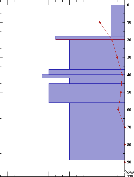
SnowPilot is open-source, free software that allows users to graph, record and database snowpit information. After creating a pit a user can print a jpg or png or download the data in xml or CAAML format. This data is automatically saved onto a secure database where researchers can analyze it. All snowpits get saved in the database and individual users can choose who can view their pits.
SnowPilot follows the US Snow, Weather and Avalanche Guidelines (SWAG) and the Canadian Observational Guidelines and Recording Standards for Snow (OGRS). All data entered is controlled by the user and error-checked to ensure a clean, robust database. As a user you get to decide who can view your snowpits: everyone, just people in your work group or no one. Regardless of your viewing choices, pits automatically populate the database for future research.
SnowPilot does not charge a fee or collect any personal data other than what gets entered, nor do we advertise or sell anything. We respect privacy. In exchange for providing a free platform to enter snowpit data, SnowPilot gets an expanding database that is readily shared with researchers to advance the field of snow science. SnowPilot snowpits have been in presentations at every ISSW since 2004. Expand our knowledge about snow and avalanches by joining the data collection effort at SnowPilot!